I faced with parking case where car goes a bit back and forth within few meters, but that causes long around routings.
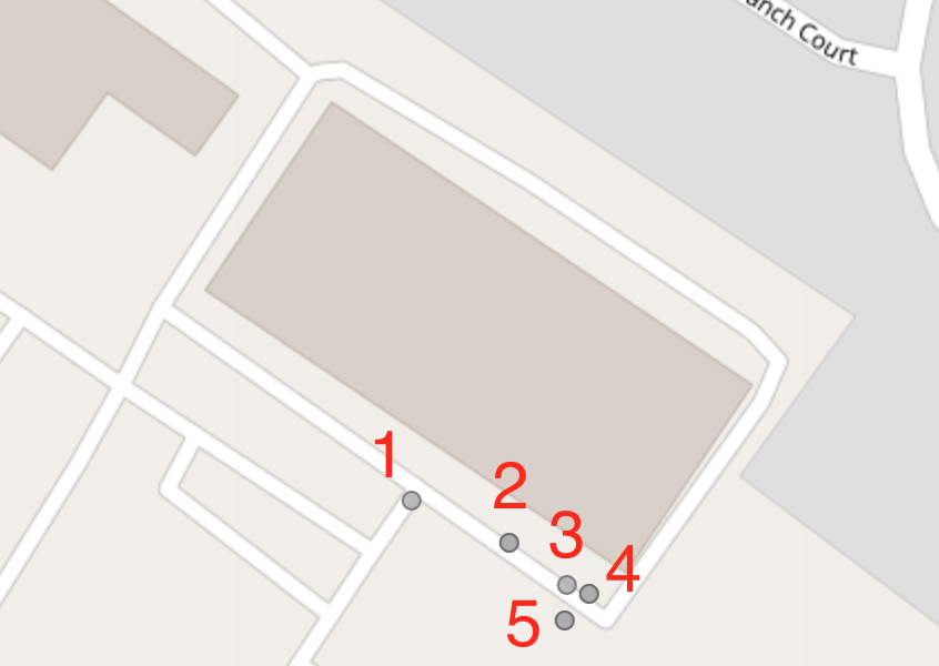
Feeding 5 points (pic and gpx attached) where points 4 and 5 at opposite road sides I am expecting algorithm to snap at already defined edge, which is 3919384 in opposite direction, however it goes all way around.
If there are any possibility to make that less strict or filter out points that goes a little(few meters) bit backwards?
I cant attach gpx files (due to limitations), so I put plain xml:
<?xml version="1.0" encoding="UTF-8" standalone="no" ?><gpx xmlns="http://www.topografix.com/GPX/1/1" xmlns:xsi="http://www.w3.org/2001/XMLSchema-instance" creator="Graphhopper MapMatching 0.13" version="1.1" xmlns:gh="https://graphhopper.com/public/schema/gpx/1.1">
<metadata><copyright author="OpenStreetMap contributors"/><link href="http://graphhopper.com"><text>GraphHopper GPX</text></link><time>1970-01-01T00:00:00Z</time></metadata>
<trk><name>GraphHopper MapMatching</name><trkseg>
<trkpt lat="30.122122" lon="-95.399362"><time>2019-12-05T22:57:21Z</time></trkpt>
<trkpt lat="30.12203" lon="-95.399128"><time>2019-12-05T22:57:30Z</time></trkpt>
<trkpt lat="30.121945" lon="-95.398987"><time>2019-12-05T22:57:36Z</time></trkpt>
<trkpt lat="30.121923" lon="-95.398932"><time>2019-12-05T22:57:42Z</time></trkpt>
<trkpt lat="30.121868" lon="-95.398994"><time>2019-12-05T22:58:33Z</time></trkpt></trkseg></trk></gpx>
match result:
<?xml version="1.0" encoding="UTF-8" standalone="no" ?><gpx xmlns="http://www.topografix.com/GPX/1/1" xmlns:xsi="http://www.w3.org/2001/XMLSchema-instance" creator="Graphhopper MapMatching 0.13" version="1.1" xmlns:gh="https://graphhopper.com/public/schema/gpx/1.1">
        <metadata><copyright author="OpenStreetMap contributors"/><link href="http://graphhopper.com"><text>GraphHopper GPX</text></link><time>1970-01-01T00:00:00Z</time></metadata>
        <trk><name>GraphHopper MapMatching</name><trkseg>
        <trkpt lat="30.122147" lon="-95.399348"><time>1970-01-01T00:00:00Z</time></trkpt>
        <trkpt lat="30.121869" lon="-95.398892"><time>1970-01-01T00:00:00Z</time></trkpt>
        <trkpt lat="30.122325" lon="-95.398516"><time>1970-01-01T00:00:00Z</time></trkpt>
        <trkpt lat="30.122411" lon="-95.398473"><time>1970-01-01T00:00:00Z</time></trkpt>
        <trkpt lat="30.12247" lon="-95.398535"><time>1970-01-01T00:00:00Z</time></trkpt>
        <trkpt lat="30.122487" lon="-95.398562"><time>1970-01-01T00:00:00Z</time></trkpt>
        <trkpt lat="30.122785" lon="-95.399075"><time>1970-01-01T00:00:00Z</time></trkpt>
        <trkpt lat="30.12302" lon="-95.399528"><time>1970-01-01T00:00:00Z</time></trkpt>
        <trkpt lat="30.123015" lon="-95.399586"><time>1970-01-01T00:00:00Z</time></trkpt>
        <trkpt lat="30.123007" lon="-95.399606"><time>1970-01-01T00:00:00Z</time></trkpt>
        <trkpt lat="30.122524" lon="-95.399967"><time>1970-01-01T00:00:00Z</time></trkpt>
        <trkpt lat="30.122147" lon="-95.399348"><time>1970-01-01T00:00:00Z</time></trkpt>
        <trkpt lat="30.121869" lon="-95.398892"><time>1970-01-01T00:00:00Z</time></trkpt>
        <trkpt lat="30.122325" lon="-95.398516"><time>1970-01-01T00:00:00Z</time></trkpt>
        <trkpt lat="30.122411" lon="-95.398473"><time>1970-01-01T00:00:00Z</time></trkpt>
        <trkpt lat="30.12247" lon="-95.398535"><time>1970-01-01T00:00:00Z</time></trkpt></trkseg></trk></gpx>