Well known route returns an incorrect result. Two months before it worked correctly for sure.
Any reason for this? Thank you.
Well known route returns an incorrect result. Two months before it worked correctly for sure.
Any reason for this? Thank you.
There might be a problem with the city. Within the city we calculate the average to be about 32km/h. You can see this with some debug options:
Is this value roughly ok? If yes, then the estimates in the rural area around the city are too high (64km/h):
We are currently preparing a change to the current “fastest” option and take into account the distance too, not just the time. You can already see the result of this approach via weighting=short_fastest&ch.disable=true
Good afternoon Peter,
thank you for precise explanation.
As I see, end point is on break between both paths (little move cause difference). I’ve compared results of GraphHopper to Google Maps and most used maps in Czech: mapy.cz . Both prefer path “over city” as faster.
I have just compared speed values of GH with my own track records from Locus testing and speed over city is correct! Maybe even little optimistic. For exactly this segment, my recording has average 6:20.
So problem seems to be optimistic speed in south/west path over villages Popovice and Polerady. I may confirm that drive here is a lot slower. Mainly this segment . I made this topic mainly because of my wife who ride yesterday in dark back home exactly by GH and this road was by her only grave. So she had to return back together with angry whispering on my and your head 
Anyway, sorry for longer post, thanks for explanation and maybe consider improving time estimates on tertiary roads without exactly defined surface. Thanks!
Just for your information
GH (over city): 9.1km, 12min
GH: 9.9km, 11min
google (over city): 9.1km, 11min:
google (same path as GH): 9.9km and even 16min
mapy.cz (over city): 9.1km, 10 min
mapy.cz (same path as GH): 9.9km, 14min
Thanks a lot for this analysis and details!
We recently got some more feedback that our rural time values are sometimes suboptimal. We need to find out in which cases one has to correct tagging issues and when it is more our fault, e.g. reducing speed for twisting roads.
Mainly this segment .
That is mainly a tertiary road and we have to decrease speed to probably something like 50km/h (?)
and this road was by her only grave.
What do you mean here?
So she had to return back together with angry whispering on my and your head
Oh … not optimal … was it not passable or just not passable in the dark?
You are of course welcome.
Sorry, one letter missing, I wanted to write “gravel”. Anyway, it is not so bad, it is just an old concrete slim road. Because in OSM seems to be no additional information compare to other roads around, I have to say that I have no idea how Google or Mapy.cz decided that this road is worst then straight over main road 244.
Maybe average speed for secondary roads 64 is out of village too low.
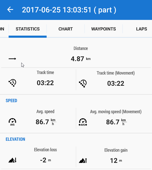
Just for your info, for this straight segment on the secondary road, this is my older recording result I’ve found (I’m not an racer)
Thanks Peter and wish you nice weekend!
EDIT:
in Czech, sec. road speed limit: 90km/h, in villages 50km/h
244 is secondary as well. So there has to be a difference even without the future bug fix for rural roads - will debug this.
Just for your info, for this straight segment on the secondary road, this is my older recording result I’ve found (I’m not an racer)
Thanks! There are two issues: currently we do not apply different maximum speed values per country and also we probably need to increase average speed for secondary roads a bit.
Please see: Better ETA values for rural areas