Hi there,
I am looking for an API that can get the exact geo coordinates along an entire route with every single intersection that went through.
For example:
I have a starting location and time (latitude , longitude, time) and ending location and time (latitude , longitude, time ). Can I find the route with all the intersections that went thru between the starting and ending location? Is that possible?
It is likely that you can achieve this via requesting the path details with edge_id:
details=edge_id
As every “edge” connects junctions you should get all the coordinates of the junctions. Although sometimes when a speed changes on a road the edge will be splitted … so certain points are not real intersections just coordinates with a speed sign. Have created an issue for it.
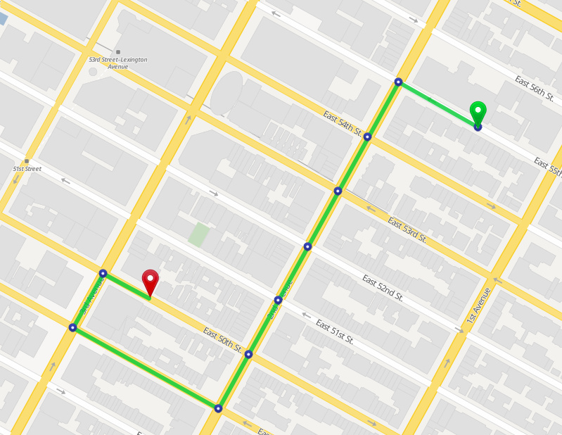
Hmm… let me give you an example. I will use Manhattan, NY.
Starting location 328 E 55th St #122, New York, NY 10022, USA ( 40.757482, -73.965040 )
Ending location 150 E 50th St, New York, NY 10022, USA (40.755541, -73.970034)
There should be 3 edges. The route would be driving on E55th Street and turn to Lexington Ave and then turn to E50th Ave. I basically want all the coordinates of the intersection between Lexington Ave with E55th St., E54th St., E53th St., E52th St., E51st and E50th St. Is that possible?
Please create a new topic and be more descriptive of your problem and what you have tried. I.e. make it others as easy as possible to help you (increases the chance of getting help).