I use the GraphHopper add-on in Locus Map on my mobile 'phone for calculating my walking routes. It works well and is my preference over BRouter. Using ‘Foot’ in GraphHopper Driving Directions at https://graphhopper.com/maps on my desktop or on my mobile 'phone, however, can produce different results. The GraphHopper add-on will take paths wherever possible what the route I would choose, in almost all cases; the Driving Directions appear to take the shortest route - this can be what route I would choose to walk but is along roads wholly in other cases.
Do you have example routes where there are differences with links to GH Maps and for locus some screenshots? Did you import the GraphHopper data with or without elevation?
Peter
Please excuse me replying by email rather than in the forum.
I believe I have been here before: I do not see where I can attach a screenshot in ‘Reply’ in the forum. Do I require your permission?
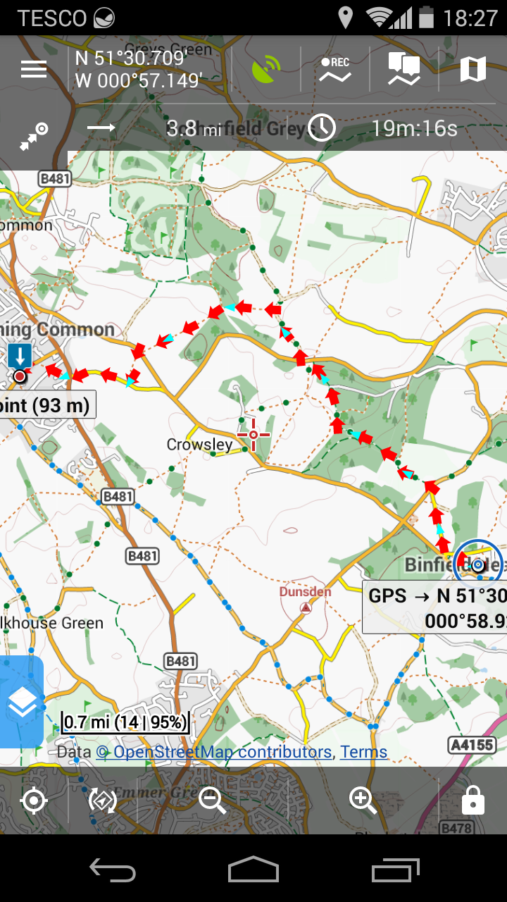
I attach the screenshot above, in any case.
https://graphhopper.com/maps/?point=binfield%20heath&point=sonning%20common&locale=en-US&vehicle=foot&weighting=fastest&elevation=true&use_miles=false&layer=OpenStreetMap shows the direct route by road with the ‘Foot’ icon selected.
The ‘Fill elevation’ box is unchecked by default in Locus Map when I import files, yet the screenshot destination point seems to show an elevation?
With regards
Bob
Which version of GH is used in Locus?
And how did you import the GH files, ie. which settings?
And which road would you consider ‘better’?
BTW: replying by email is fine as it appears in the forum too. Or try:
Peter
I thank you for your reply.
I use successfully every two or three months since eighteen months or so when you helped me first, Geofabrik data with Locus Map Menion’s generator that is on Google Drive, processing it with Cygwin. I was unable to get Locus Map to accept what I prepared using GraphHopper Quickstart.
I copy the resulting *.osm-gh file to my 'phone’s Internal storage\Locus\data\import and use Locus Map’s import function directly. I am extremely happy with this process and result.
The route in the screenshot from my 'phone is absolutely correct for a walker, which is the most important factor. It is simply more convenient at times to look at proposed routes on my desktop but it produces what was in the .url. I am forced to help the route then by inserting via points.
The differences can have many reasons. Like different GH version (we use a relative recent build on GH maps), an up to data map (we update every day) and elevation. Hard to judge.
I am extremely happy with this process and result.
Nice to hear this ![]()
Hello guys,
GraphHopper in Locus Map is little outdated now. Update on latest version 0.9 is currently in preparation.
Only after that ( and also after update of GH routing data ), you may expect same results of routing.
1 Like
Menion
Just for the record: it is GraphHopper in Locus Map that gives me the walking routes I would expect; GraphHopper Driving Directions from its own website take me along motor roads rather than footpaths. It is that which I cannot understand; I am perfectly happy with GraphHopper in Locus Map
Bob