Hello! Thanks beforehand for your amazing project, it is super interesting.
I have 2 questions.
Based on your experience, what are the scenarios that point_hint solves?
I saw in your documentation, and in the forum, that in cases where the coordinate (lat,lng) is very close to intersections or very close to overlapped edges, it helps to finally choose the right edge. But based on your experience, are there more scenarios where point_hint helps?
What do you think about implementing a custom alternative_snap_point? With this approach instead of passing a hint, to finally help the routing engine to find the right edge, we pass directly the alternative snap point the routing engine should use. Somehow gives the ability/control to the client to decide where is the snap point. Do you think this is a good practice? Could it be an antipattern?
In our experience the point_hint (and snap_prevention) helps our customers in many situations, yes.
With this approach instead of passing a hint, to finally help the routing engine to find the right edge, we pass directly the alternative snap point the routing engine should use.
I do not understand this suggestion. If it has the right point why not pass this point directly?
And why would there be two points (how would the client obtain it?) and how should the routing engine decide which point to use? Can you explain in more detail what you mean?
Sure, let me try to explain it better.
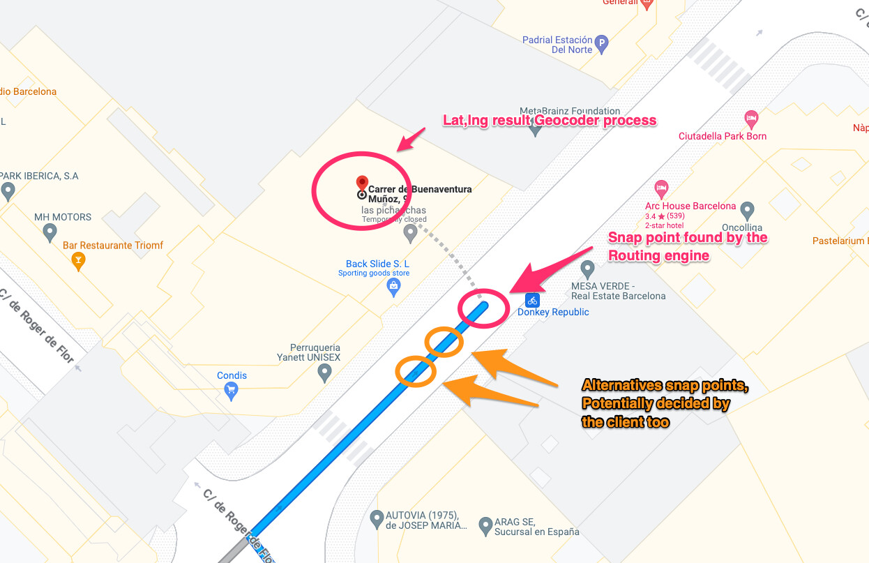
If I understood well, the lat,lng provided by the client is the result of the Geocoding process. So given a postal address, the Geocoder returns a lat,lng. This lat,lng usually stands in the center of the building. Therefore is not where the real route starts, as potentially there are some meters to walk between the real destination (original lat,lng) and the real start of the route for the specified vehicle (snap point). Usually, this difference in meters is represented with dots in the user interfaces.
Somehow the point_hint is to help the Routing Engine find the point, What I am saying is why not allow the clients to decide exactly what is that point?
So I guess, what I am saying doesn’t make sense because that would imply hardcode Snap points, and the road network is changing and it wouldn’t be maintainable.
I guess the postal address concept is the abstraction for that, as it is a human-readable concept, and for this reason is not a good practice to expose this feature of manipulating directly the snap point from the client’s point of view.
Maybe I have answered myself, but I would appreciate if you can give me your point of view
Thanks
Companies do similar things to improve the precision: they map certain lat,lng (or even an entire bounding box) to a specific different lat,lng (like the entry of the building). But instead of providing this new lat,lng as “alternative snap point” to the routing engine you can just use this point directly instead of the original point.
But then you need to establish a process to track the performance of these manual mappings…as the road network is changing, these ad hoc mappings could start to degrade the quality of the routes.
In any case…I see it like a last step to increase precision if necessary, after using other capabilities of the Routing Engine , like snap_preventions, or point_hint